
Mathematics, 07.10.2020 14:01 yo2lo15
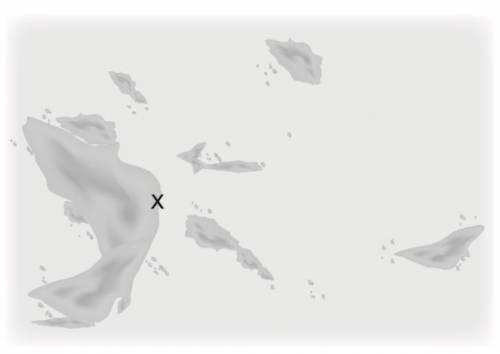
Using the starting position marked as an X on the map below, use a ruler and protractor to navigate the ocean. Use a metric ruler as your chart plotter and let 1 centimeter represent 1 nautical mile when you are plotting. Travel north for 30 minutes at 6 knots, and then travel east for 45 minutes at 4 knots. Sketch your path and ending location on the map.

Answers: 2


Another question on Mathematics
Mathematics, 21.06.2019 20:00
Evaluate the discriminant of each equation. tell how many solutions each equation has and whether the solutions are real or imaginary. x^2 - 4x - 5 = 0
Answers: 2
Mathematics, 21.06.2019 20:30
Astore ordered 750 candles a total wholesale cost of $7910.20. the soy candles cosy $12.17 each and thespecialty candles cost $9.58each. how many of each were bought?
Answers: 1
Mathematics, 21.06.2019 21:30
Hannah paid $3.20 for 16 ounces of potato chips. hank paid $3.23 for 17 ounces of potato chips. who paid less per ounces?
Answers: 1
Mathematics, 21.06.2019 22:40
20.ju inces. which ordered pair is a viable solution if x represents the number of books he orders and y represents the total weight of the books, in ounces? (-3,-18) (-0.5, -3) (0,0) (0.5, 3)
Answers: 1
You know the right answer?
Using the starting position marked as an X on the map below, use a ruler and protractor to navigate...
Questions


Mathematics, 08.07.2019 11:00

Geography, 08.07.2019 11:00


Social Studies, 08.07.2019 11:00

Biology, 08.07.2019 11:00

History, 08.07.2019 11:00


