
History, 20.11.2020 19:50 laurieburgess804
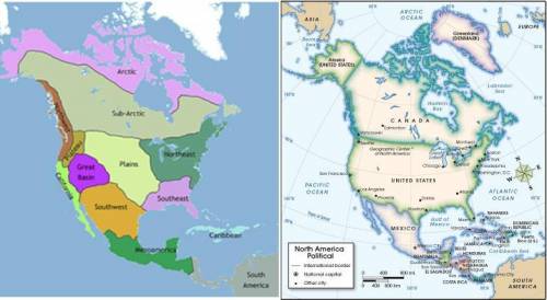
PLZ HELP ASAP IM ON A TIME LIMIT First image. Map of North America showing the regions in which Native American tribes lived in ancient times. The Arctic and sub-Arctic are at the top of the continent, respectively. On the west coast, California and the Northwest region are labeled. Slightly interior to the west coast are the Plateau region and the Great Basin. Beneath and east of the Great Basin is the Southwest, which borders the Plains to its East and Mesoamerica to the south. South America is labeled, to the southeast of Mesoamerica. The Plains takes up a large portion of central North America. The Northeast and Southeast also are labeled, east of the Plains and extending to the Atlantic coast. The Caribbean islands are seen off the Southeast coast. Second image. Political map of North and Central America. The United States appears in between Canada to the north and Mexico to the south. Alaska is seen as a peninsula off of western Canada. In the United States, the cities of Seattle on the northwest coast, San Francisco and Los Angeles on central and south west coast, respectively, Phoenix in the southwest, Dallas and Houston in the central south, Chicago in the central plains area, Atlanta in the southwest, and Boston, New York, Philadelphia, and Washington D. C. in the northeast are labeled.
© 2012 The Exploration Company
Compare the two maps. Based on these maps, in which regions would Native Americans who lived in the area where modern-day Chicago is be classified? (4 points)
a
California
b
Arctic
c
Plains
d
Northeast

Answers: 1


Another question on History
History, 21.06.2019 20:00
The maps below show the middle east. which best explains how the green areas depicted in the image on the left are reflected in the population map on the right? populations are greater in fertile areas that are close to freshwater sources, which is why more people live near deserts. populations are greater in fertile areas that are close to freshwater sources, which is why more people live near oceans. populations are greater in fertile areas that are close to freshwater sources, which is why more people live near mountains. populations are greater in fertile areas that are close to freshwater sources, which is why more people live near rivers. plz hurry in test only have 34 mins left
Answers: 1
History, 21.06.2019 23:30
How do you think american life would change greatly, as soldiers went to war in europe?
Answers: 1
History, 22.06.2019 05:00
In the period from 1860 to 1890, which experience was shared by most native americans living in western states?
Answers: 1
History, 22.06.2019 06:30
Which directions did the mongols travel as they swept across asia and europe
Answers: 1
You know the right answer?
PLZ HELP ASAP IM ON A TIME LIMIT First image. Map of North America showing the regions in which Nati...
Questions


Mathematics, 28.07.2020 04:01
Mathematics, 28.07.2020 04:01
Mathematics, 28.07.2020 04:01
Mathematics, 28.07.2020 04:01
Mathematics, 28.07.2020 04:01


Social Studies, 28.07.2020 04:01
History, 28.07.2020 04:01
Mathematics, 28.07.2020 04:01
Mathematics, 28.07.2020 04:01


