Understanding orientation
the eastern front (world war i)
masurian lakes
this map...

Geography, 17.07.2019 23:30 chrissy5189
Understanding orientation
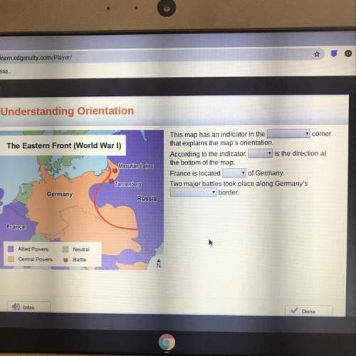
the eastern front (world war i)
masurian lakes
this map has an indicator in the
corner
that explains the map's orientation.
according to the indicator
is the direction at
the bottom of the map.
france is located of germany.
two major battles took place along germany's
border.
tannenberg
germany
russia
france
neutral
alied powers
central powers
battle
i have to finish geo in 8 days

Answers: 1


Another question on Geography
Geography, 21.06.2019 17:00
How do the dry pampas and wet pampas contribute to the economic health of argentina
Answers: 3
Geography, 22.06.2019 22:30
At which point on the diagram do convection currents occur to drive plate movement?
Answers: 1
Geography, 23.06.2019 09:00
What can you learn about precipitation levels in south america from this map? brazil is experiencing a drought.it rains more in higher altitudes.peru received the highest level of rain.venezuela got less than 25 cm of rain.
Answers: 2
Geography, 23.06.2019 13:00
What is one difference between austria and switzerland? a. austria is landlocked. b. austria has more minerals resources c. austria has a strong tourism industry d. austria has a strong dairy cattle industry
Answers: 1
You know the right answer?
Questions


Business, 02.11.2020 23:30


English, 02.11.2020 23:30

Biology, 02.11.2020 23:30

Mathematics, 02.11.2020 23:30
Mathematics, 02.11.2020 23:30
Mathematics, 02.11.2020 23:30


